Mount Krn, located in Slovenia Soca valley near Kobarid, is one of the southernmost mountains of the Julian Alps. The Italians call it “Monte Nero”, “Black Mountain”. With its grassy slopes and the bright Karst landscape, so popular with outdoor enthusiasts, it looks anything but what the name suggests. With its 2,244 meters, Krn is one of the highest mountains in this particular region in Slovenia.
Mount Krn – a historic mountain

Like as many – or indeed any – peaks around the Soca valley and Mount Krn, the First World War played an important but never-the-less sad role. During the battles of Isonzo (1915-1917) front-line action took place here between Italy and Austria. The Italian Alpini fortified themselves on the summit of Mount Krn and hollowed out numerous caverns as hold-outs. Fierce battles against the Austrian army were fought – mountain warfare, which on both sides not only cost thousands of soldiers lives, but also a part of Krn’s summit. Due to the strong artillery fire, the summit was literally in ruins and today measures less than a few meters than it was before the war. Mount Krn has become an involuntarily and eternal memorial for the “Grande Guerra”. This mountain, with its rich and dark history we indeed wanted to climb!
Starting point: The mountain village of Drežnica in Kobarid
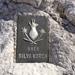
One day in early October, as is so typical of the Slovenian Soca valley: shrouded in fog making the surrounding mountains barely visible. The weather forecast promises sun and so we set out to Drežnica, a small mountain village above Kobarid. From there we commence our hike, equipped with a helmet and via Ferrata set. We have chosen the most difficult route up to Mount Krn via the west wall, which includes the via Ferrata “Silva Koren”. Who knows, we may find its “dark” side.
We set out early morning with the car and estimated about eight and a half hours of pure walking or climbing time – Kobarid via the Napoleon bridge to the other side of the emerald Soca and further up on the small asphalt road until we reach Drežnica. The small mountain village is well known for its goats, the Drežnica goat. This is the only recognized autochthonous Slovene breed of goats. Together with the Bovec sheep, there are ample to be seen grazing in meadows and on the slopes of the Julian Alps mountain region. A hardy, proud animal that is made for mountain life.
One mountain village, lots of goats, few hikers: The ascent to Mount Krn

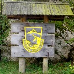
The mountain village Drežnica lies at 540 meters above sea level. Our aim was an elevation of 2,244 meters – meaning there were 1,700 meters before us to climb before we reached it. There was no confusion that we were in the wrong place – blocks of steep trails and a wooden signpost with the wording “Krn” the first signs of Drežnica goats and the Triglav National Park waiting for us behind the vast meadows.
After some time the road forks out and we keep in the direction of “bivouac”. After passing the “bivouac na Crniku” the route extends into the West wall. Those who follow the sign “Krn” will hit the “Planina Kuhinja” trail – located at 1,000 meters above an alpine meadow of the village of Krn. This trail is the so-called “normal”, track selected by most hikers. “Most” should be taken lightly though as most hikers aren’t to be found in the Soca valley – and certainly not in the autumn months. We don’t see a soul for the next few hours. It’s not until we reach the summit that we come across our first fellow trekker – one, lone traveller within a space of nine hours -we could get

use to this!
Entry into the Silva Koren via ferrata
We continue our ascent to the bivouac (1,160 meters), which we reach after about one and a half hours. Well hidden in the forest, the small wooden hut is nestled into the hillside. There is freshwater from a spring in the form of a goat’s head and a book from the Slovenian Alpine Club, in which we record our details. Continuous, steep ascents lead us to the Silva Koren-Ferrata at approx 1,400 meters. After a hard, long hour we finally arrive. First, the climb leads us through a deep gravel ravine before we come to the wire cables – earlier in the year, there is still snow, the remains of which can still be seen.
Climbing through the clouds

exertion.
Straight onto the rock, partly secured with wire cables, however more often than not it’s just free-climbing and mountaineering. It goes without saying that a hiker at these levels needs to be comfortable with heights, sure-footed and of course, be wearing good, quality hiking boots. We soon realise that the ascent is not generously equipped with ropes and with the fog blocking our vision at times, allowing us to see only a a few feet in front of us, we wonder out loud where Mount Krn has disappeared to. It doesn’t take us long to figure out, that at this time of the year we have reached the ceiling at 1,500 meters, yep, we’ve arrived at the clouds so to speak. An incomparable view, even if the visibility is limited.
Soon we are rewarded for our arduous climbing effort, when we step out at about 1,600 meters from the clouds and there, spread out in all their glory is the chain of the Julian Alps. Peaks and ridges protrude from the billowing sea of clouds below us and above us the radiant sun and a mighty blue sky. At 1,700 meters we reach a small platform from where the “true” via Ferrata begins – we are certainly hoping for more rope than we previously had, however, it looks like the climb is at a bare minimum, so it’s a matter of look at the rock and not down – and thank goodness the clouds have been gracious enough to block our view of the depths below! Up, up to climb Mount Krn’s summit. The warm, dry limestone keeps the ground dry and solid and the views that we are presented with make the exertions of the last 500 altitude meters fly by. Two ladders and a pillar to climb, and before we know it the trail has spat us out at the Krn hut (2,210 meters). The ascent took us five hours to complete.
360-degree panorama in the heart of the Julian Alps
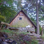
The hut, open during summer – and even then sparsely managed, has a winter shelter that we don’t feel the need to use. The sun is shining and we want to enjoy our snack on the wooden benches on the terrace with a magnificent view. However, there are still the few remaining feet to the summit left to climb – past the remains of a cavern, reminding us that we are moving on historic ground. Even the top terrain of Mount Krn resembles the shape of a garbage pit with its flat landscape and leaves no doubt as to what had once gone down here. The panoramic spectacle, which is ours for the taking soon lets us forget the dark side of the mountain’s history! We cannot get enough of this 360-degree panorama!
A descent through Tolkien’s Middle-earth

After a leisurely lunch break, we make our descent. We choose the “normal route” towards Planina Kuhinja and cork-screw our way downhill in countless switchbacks until we turn towards Drežnica and plunge back into the clouds and fog. It’s like stepping into Tolkien’s Middle-earth, as we now change towards Crznik, the mountain ridge, which is upstream of Mount Krn on the other side. Here we once again pass numerous caverns that appear like black eyes on the slopes peeping sinisterly out of the fog. We briefly peer into a few of them – the time is against us however and we want to be down at the valley bottom before nightfall. Two and a half hours later we meet up again with the ascent route, the point where we took the route this morning over the bivouac and the via Ferrata. Past the Drežnica goats again and after about three hours of descent, we are back in the parking lot near the church. Done – after around nine hours!
An unforgettable experience in the footsteps of European history is behind us and we are overwhelmed by Mount Krn and its history – undoubtedly a dark one. With this in mind, the name “Monte Nero” is perhaps justified after all.
Info Krn and Soca valley
- Hiking on Mount Krn: Total of eight to nine hours schedule for the tour to Mount Krn. Best times are the summer months and autumn, caution should be exercised after snowfall. A starting point for the tour is the mountain village Drežnica, which is accessible via the Napoleon Bridge from Kobarid.
- Silva Koren: The climbing on Mount Krn is a physical challenge with over 900 meters of altitude difference. Keeping the technical difficulties with 3-B / C graded trail within limits, the tour requires a high degree of alpine experience because the trail runs almost continuously through risky no-fall zones. In addition, more delicate passages must be mastered in part without cable lines.
- Map & Guide: via ferrate Julian Alps from Alois Goller and Hanns Heindl, Rother publishers . Kompass Map 2801 Julian Alps – Steiner Alps, 1:75.000
- Getting there: The Soca valley with its outdoor sports centres Bovec and Kobarid can be reached via the Austrian A10 (Tauern motorway) from Germany and Austria. Coming from Villach, take the exit Tarvisio (toll-free) shortly after the Italian border. From here the Predil Pass, then Bovec and Kobarid are signposted.
- Outdoor paradise Soca valley: The Soca valley attracts year-round outdoor sports enthusiasts to Slovenia. During the winter, the ski resort Kanin-Bovec has a reputation as being a “snow hole” whereas, come spring, he river Soca is the main event and the first kayakers start appearing in the valley. The summer months especially are popular in Soca for water sports (kayaking, rafting, canyoning, hydrospeed), but also fly-fishing. The surrounding Julian Alps attracts mountain climbers, hikers, paragliders, hang gliders and mountain bikers to the region.
- Accommodation: The Soca valley caters incredibly well to its outdoor-loving guests. On the banks of the beautiful Soca river, in Kobarid, Bovec and Trnovo, numerous top-quality campgrounds are to be found. Appartments, guesthouses and hotel accommodations are also available in the nearby towns of the Soca valley.
- Culinary Tips: Great fish dishes are to had in Restavrancija Kotlar and in the centre of Kobarid in Bistro Camp Lazar, great crepes and grilled trout are on the menu. The Bovec Letni Vrt has a huge selection and the best pizza in the valley. The matching dessert’s right next door in the small pastry shop.
- Museum: The museum at Kobarid offers a comprehensive insight into the sad story of the Soca valley.
More adventure reading in the Bergzeit Journal: